Blog

  • Madagascar – Indian ocean Crossings

    Although the “Island of Fire” was never “off the map,” to Srivijayan-era sailors, it was not a short trip either. With the South Equatorial Current and monsoons, a direct crossing from Sumatra to Madagascar would be demanding, yet perfectly doable for the experienced Austronesian navigators that had already made the Indian Ocean their workplace. In fact, for those that could dependably make the scheduled voyage from China to India, adding Madagascar into the route was an expansion of a known practice, and not a wild leap into the unknown.
    This is my third post on this fascinating, and very rarely discussed historical connection between the Sriwijaya and Madagascar. The first is an introduction, the second is academic discussion of proof.

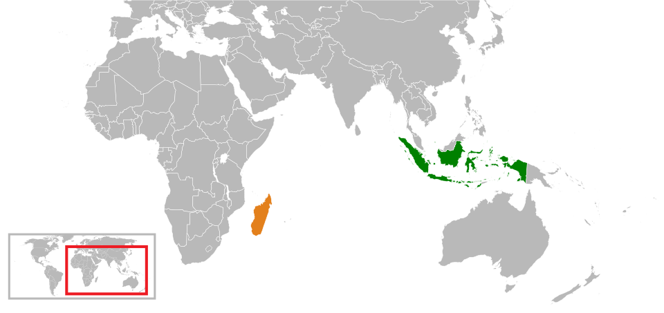
    DNA Dates, Srivijaya’s Height and the Culture of Making Long Voyages


    Genetic research on the Malagasy population places the earliest founding of Austronesian populations in Madagascar approximately during the first thousand years of the Common Era (CE), with a notable study identifying the largest Indonesian maternal founding event in close proximity to 830 CE, and involved in the process of introducing approximately thirty distinct maternal lineages. This dating corresponds to the peak of Srivijaya’s influence in South Sumatra, when Palembang functioned as a significant entrepot between China, India and the Arab World.

    RElief of a traditional sialing shop on borobudur, indonesia
    Relief of a saling ship on Borobudur temple – carved in the 8th century.

    The wealth and political influence of Srivijaya rested upon its control over the Malacca and Sunda Straits, where it taxed and serviced ships that traveled between the South China Sea, the Bay of Bengal and further west.

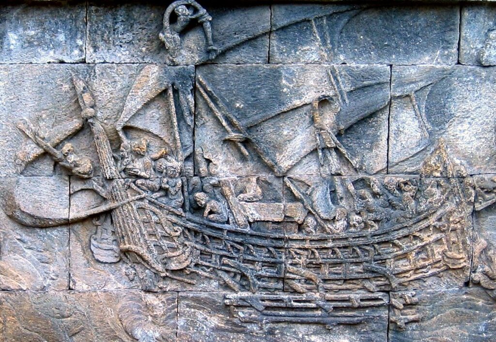
    As a whole, Austronesian peoples were already accomplished blue-water sailors, employing outrigger and plank-built vessels that allowed them to traverse wide ocean expanses prior to the days of medieval European explorers.

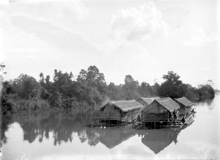
    When meeting with shipbuilders in the Riau Islands or South Sulawesi today, there remains a living remembrance, almost casual, of long monsoon voyages to distant ports; the attitude described by Srivijayan-era sources, simply scaled up and directed to the broader Indian Ocean.

    The South Equatorial Conveyor Belt: A “Straight Line” to Madagascar


    To some extent, modern oceanography makes the direct route from Sumatra to Madagascar appear much easier than previously imagined by older armchair historians.

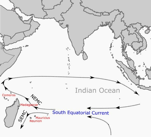
    During the period of May to November, when trade winds and Indonesian Throughflow waters reinforce it, the South Equatorial Current in the southern Indian Ocean flows westward, carrying water (and any boats present in the water) from the vicinity of Indonesia towards Madagascar and the Mozambique Channel.

    Both historical and modern sailing guides indicate that when the passage is timed correctly to match the seasonal flow of the current, a journey along this route is possible; numerous yachts currently make the crossing to Madagascar via similar latitude and typically spend about 21-28 days at sea.

    Austronesian pilots employed a combination of stellar navigation, and determining rising and setting points of important stars; in addition, they employed mental maps of wave directions, wind patterns and star paths.

    When combined with a west-flowing current and consistent trade winds, a “road” of sorts exists in the Indian Ocean for sailors; historians state that once the seasonal patterns of the monsoons were understood, long-distance trade between Southeast Asia, India and the western Indian Ocean increased significantly.

    A notable example that has been frequently cited by scholars: pumice from the 1883 Krakatoa eruption in Java washed up on Madagascar’s east coast in less than three months, providing graphic proof that floating objects (including hulls) may travel along the same westerly path across the basin without supernatural assistance; for sailors accustomed to intentionally targeting landfalls many kilometers apart in the Pacific, following a rail of currents and monsoons from Sumatra to a relatively large island such as Madagascar falls well within their ability.

    From sitting on a small wooden deck in eastern Indonesia, observing an older nakhoda “measuring” our course with reference to a star he refers to locally rather than a star identified in a Western almanac, it is harder to conceive of them not utilizing the same method to extend their voyaging further west when cargo, politics or plain curiosity aligned properly. The Indian Ocean was not an obstacle; it was merely a medium.

    Revisiting “Impossible” Crossings


    Considering all of the above, the image appears to be less a story of a single heroic “first crossing” and more a reasonable continuation of Srivijayan-centered, Austronesian seafaring culture into a portion of the Indian Ocean in which the physical properties of the ocean support them.

    -A westward flowing current, strengthened by seasonal reinforcement originating in Indonesia and heading towards Madagascar

    -A well-understood monsoon system that supported trade between Srivijaya, India, Sri Lanka, and the Arab world

    -Proven capacity among Austronesians for navigating large distances across the open ocean and constructing vessels capable of such voyages

    -Genetic evidence indicating a considerable, organized migration of Austronesians to Madagascar during the height of Srivijaya’s influence

    From the perspective of someone who spends a great deal of time in Indonesian ports listening to captains discuss routes, the notion of a direct Sumatra-Madagascar crossing ceases to feel like speculative fantasy and begins to resemble precisely what these communities have always practiced: read the sky and the sea, rely on the vessel, navigate the seasons – and return to your destination in a manner that is more intelligent than the route you took to get there. To see the problem as a matter of “how did they manage to go to Madagascar?” is to misunderstand the nature of the question; the question is better phrased as “how did they manage to go to Madagascar regularly?”


    Tripati, S. (2006). Monsoon wind and maritime trade in the Indian Ocean (1000 BC–AD 1500). Current Science, 90(6), 864–873.

    Chen, G. (2022). Seasonal structure and interannual variation of the South Equatorial Current in the Indian Ocean. Journal of Geophysical Research: Oceans.

    Campbell, G. (2009). Austronesian mariners and early trans-Indian Ocean crossings. In Navigating African maritime history.

    Wikipedia contributors. (2003– ). Srivijaya. In Wikipedia, The Free Encyclopedia.

    Blench, R. (2015). Evidence for the Austronesian voyages in the Indian Ocean. In G. Campbell (Ed.), East Africa and the early trans-Indian Ocean world interchange.

  • Madagascar – Further proof of the connection

    Madagascar was not just a distant dot on Srivijaya’s mental map of the Indian Ocean; it sat on the outer edge of a trade system that pulsed with cloves, cinnamon, ivory, gold and stories of terrifying pirate raids and unlikely alliances. This follow‑up isn’t about “were Indonesians there?” anymore, but about what they actually did there – what moved through those harbours, who profited, and how often the line between trade and raiding blurred. This is following up on my previous post

    Standing on a Shore That Faced Sumatra

    When that old Stiles article on East African, Comorian and Malagasy ports finally clicks into place, Madagascar stops feeling like a far‑flung Austronesian miracle and starts looking like a working component of an Indian Ocean logistics system. From about the 9th to the 15th century, the East African coast, the Comoros and northern Madagascar were threaded into the same network that linked Srivijaya’s heartlands in Sumatra to India, Arabia and, indirectly, China.

    By the 9th century, Malagasy ports like Irodo were already handling Indian glass beads and chlorite‑schist vessels, plugged into the same circuits as Kilwa, Manda and Mafia in East Africa.

    The Comoros, especially Dembeni on Mayotte, emerge in the archaeology as a kind of stepping‑stone arc between the Swahili towns and Madagascar – small, but busy, and clearly oriented to maritime exchange.

    When sitting in a kampung in eastern Indonesia, listening to fishermen joke about “orang Arab dulu ikut angin” (the Arabs once just followed the winds), the map from that article feels strangely familiar. It is the same monsoon logic Nusantara sailors still talk about, just stretched all the way to Sofala and beyond.

    What Actually Moved: Commodities of an Ocean Highway

    The Stiles piece reads like someone reverse‑engineering a medieval shipping manifest. Once that is layered onto the genetic and linguistic evidence from the first post, the trade picture between Srivijaya’s world and Madagascar gets much more concrete.

    Flow out of Madagascar and the islands

    From northern Madagascar and the Comoros, several key exports show up repeatedly:

    Chlorite‑schist vessels and objects

    Carved stone containers from northern Madagascar (especially Irodo and later Vohemar) are found in East African ports like Kilwa, Manda and Mafia, with the earliest examples dated to the 9th–11th centuries. These are not random curios; they look like prestige containers that would have travelled well inside elite and merchant circles.

    Gum copal, beeswax and medicinal herbs

    Stiles lists chlorite‑schist, gum copal, livestock, rice, beeswax and medicinal herbs as Malagasy exports feeding into the wider Indian Ocean trade, especially via Sofala and Kilwa. Copal and wax are classic “quiet” commodities – small, valuable, easily stowed on long voyages from Sumatra or southern India.

    Rice and livestock

    By the later medieval period, Madagascar appears as a provisioning node as much as a source of exotica: rice, animals and possibly other foodstuffs supported traders moving between Sofala, Kilwa, Arabia and beyond. This fits well with the Austronesian rice‑cultivation expertise already visible in Malagasy highland culture.

    Goods coming in from the Srivijayan sphere

    On the inbound side, the article makes clear that Indonesians – identified in Arabic and Chinese sources as Zabag, Kun‑lun or Wak‑Wak – were part of the same spice‑heavy traffic that Srivijaya is famous for.

    Cinnamon, cassia and aromatics

    Miller’s “Cinnamon Route,” which Stiles references, imagines Indonesian ships bringing cinnamon and related aromatics from Southeast Asia down to the southern East African coast and the islands. Whether or not the route was quite as direct as Miller sketched, Indonesian traders are consistently associated with high‑value spices, benzoin, camphor and other forest products that were prized in the western Indian Ocean.

    Iron, copper and manufactured goods

    In the 8th-11th centuries, ports from Somalia to Mozambique are receiving iron implements, copper, cloth, ceramics and beads from South Asia and the Gulf. Indonesians were very likely part of this system: Stiles notes that the same ports linked to Srivijaya by al‑Idrisi, especially Sofala, were exactly where these goods were circulating.

    Indirect Chinese and Southeast Asian wares

    Even when Chinese goods did not arrive under a Chinese flag, they filtered through Indian and Indonesian traders. By the 12th-15th centuries, some of what washed up in Madagascar and the Swahili towns – porcelains, fine stonewares – probably came in hulls that had sailed through Srivijayan or successor harbours in Sumatra and the Malay world.

    When thinking back to handling Song and Yuan ceramics laid out on the floor of a Palembang collector’s house, it suddenly makes sense that similar wares show up in East African contexts. The same ships that stopped in Sriwijaya’s harbours fanned out with cargo that eventually touched Madagascar’s shore.

    Zabag, Wak‑Wak and Kanbalu: Trade, Raids and Reputation

    The most dramatic part of the Stiles article for anyone obsessed with Srivijaya is the cluster of Arabic references to Zabag (Zabaj), the Wak‑Wak people and this mysterious island fortress called Kanbalu.

    “They came in a thousand boats”

    Buzurg ibn Shahriyar, a 10th‑century Persian writer with both a flair for drama and surprisingly useful details, describes “Wak‑Wak” seafarers arriving off Kanbalu in 945–946 CE with a fleet of a thousand boats. When asked what they wanted, they replied that they had come for products desired “in their own land and in China”: ivory, tortoise shell, panther skins and ambergris.

    This is explicitly framed not as peaceful trade but as an attempted raid; they attacked the fortress and eventually withdrew when they failed.

    Stiles underlines what often gets glossed over: in this early phase, Indonesians in African waters had a reputation not only as merchants but also as dangerous raiders.

    As someone used to hearing Bugis or Butonese raiding stories in eastern Indonesia, the Wak‑Wak episode feels oddly familiar: trading and raiding are just different strategies along the same maritime frontier. The line is thin when your ship, crew and weapons are the same either way.

    From Wak‑Wak raiders to Zabag traders

    By the 12th century, the tone shifts. Al‑Idrisi writes that at Sofala, the Zanj Africans traded with people from the Indonesian empire of Srivijaya (Zabag) and that they “spoke the same language” and were well received.

    Stiles reads this as a move from a raiding phase (Wak‑Wak in the 10th century) to a more settled phase of recognized trade by people identified with Srivijaya in the 10th–12th centuries.

    Hostilities between Africans and Zabag are still mentioned in some sources, but by al‑Idrisi’s time, the emphasis is on shared language and regular exchange, especially in Sofala’s gold trade.

    This is the kind of line that nags at you when you’re talking to traders in South Sumatra: an Arabic geographer in 1154 saying that East African Zanj and Srivijayan merchants understood each other, and that Zabag ships were familiar visitors at Sofala’s harbour. The Indian Ocean starts to feel much smaller.

    Madagascar in the Middle: Routes, Stopovers and Silent Evidence

    The Stiles article is strikingly honest about one key problem: there is very little direct archaeological proof of Indonesians on the African mainland, and even Madagascar’s early material record is thin. But when the pieces are lined up, Madagascar still sits right in the middle of plausible Srivijaya–Africa routes.

    Possible sailing routes

    • A near‑direct crossing of roughly 6000 km from Indonesia to Madagascar, riding the monsoon winds.
    • A staged route via southern India and the Maldives, then across to East Africa.
    • A long circumnavigation of the eastern and northern Indian Ocean, then down the East African coast – essentially a grand loop.

    He suspects, reasonably, that multiple routes were used over the centuries. Linguistic evidence tends to place the split of Malagasy from its Southeast Barito cousins around the 3rd-4th century CE, even though the earliest dated human habitation on Madagascar is only from the late 7th century. That time lag leaves space for a long period of maritime experimentation, trade and maybe failed or forgotten attempts before stable settlements took root.

    Why the archaeology is so frustrating

    One of the most sobering parts of the article is the section on sea‑level fluctuation.

    Ports like Ras Hafun and India’s Dwarka show that harbours were often built when sea levels were slightly lower; later rises drowned or eroded them.

    Underwater and eroded sites around Pemba, Mafia and perhaps parts of Madagascar likely hide many of the structures we would dream of finding as “proof” of Indonesian settlement or permanent trade stations.

    For someone used to wading through mangrove mud near old harbours in Sumatra, that feels painfully real: pottery, glass and beads cling on; wooden jetties, small warehouses and beached hulls just vanish. Madagascar may have been busy long before the earliest layers we can currently date.

    So Was Madagascar a Sriwijaya Colony – or a Partner?

    Putting the linguistic, genetic and Stiles’ trade evidence together, Madagascar looks less like a classic “colony” and more like an Austronesian‑founded society that was plugged into Srivijaya’s commercial orbit.​

    • Linguistics and DNA point firmly to Southeast Borneo and South Sumatra as sources of population and language for the Malagasy.​
    • The trade record shows Madagascar exporting regionally valued raw materials and provisions while importing prestige goods, beads and possibly Southeast Asian plants via Indian and Indonesian shipping.​
    • Arabic texts explicitly connect Sofala’s trade to Zabag/Srivijaya and describe both conflict and collaboration between Indonesians and East African communities.​

    From a modern Nusantara perspective, it almost feels like looking at a distant cousin port: same Austronesian backbone, different mix of African and Islamic overlays, but operating under the same monsoon logic that once tied Palembang, Gujarat, Aden, Kilwa and northern Madagascar into a single, messy, living system. Not neat, not fully documented, and full of gaps – but absolutely real.​

    Stiles, D. (1992). The ports of East Africa, the Comoros and Madagascar: Their place in Indian Ocean trade from 1 – 1500 AD. Kenya Past and Present, 24, 25 – 36.

  • Jambi Lions – Emerging from the river…

    Jambi Lions – Emerging from the river…

    Jambi Lion - coin from personal collection.
    Example of a Jambi Lion – copper coin, commonly attributed to the Sriwijaya empire

    Few single objects have done more to ignite public fascination with the shadow-shrouded Srivijaya empire than the Jambi Lion copper coins. Virtually unknown to scholars and collectors a decade ago, the pieces began appearing only after intensive dredging of a single stretch of the Batang Hari/Kumpeh river system, and genuine finds remain overwhelmingly confined to that locality. Because they are struck in bronze (potentially the earliest securely provenanced copper-based coinage yet identified in Indonesia( there is some hand-wringing in academic circles. Auction catalogues now label every specimen “rare” and “under-studied,” yet bidding routinely climbs into the hundreds of dollars as museums and private collectors scramble to secure an example. In short, a coin that barely registered outside a handful of river divers ten years ago now stands at the center of both a market frenzy and fresh academic debates over Srivijaya’s economic reach, while remaining tantalizingly undocumented in formal literature.

    Standing (wobbling) on the deck of diving boat on the murky waters of the Batanghari River system, watching local divers surface with handfuls of ceramics, random pieces of metals and corroded bronze, you realize some archaeological discoveries happen not in sterile university excavations, but in the chaotic reality of Sumatra’s river ports. The Jambi Lion coins represent exactly this kind of serendipitous revelation, a completely unknown coinage system that has rewritten our understanding of medieval Sumatra’s commercial sophistication, emerging piece by piece from the silted channels around Muara Kumpeh.

    Discovery at the Confluence

    The story begins at Suak Kandis village, where the Kumpeh River meets the mighty Batanghari, roughly 50 kilometers downstream from modern Jambi city. This isn’t some remote backwater—it’s a strategic confluence that the Dutch recognized when they built a fort here in the early 18th century. It was a sensible place ot build a trading fort (it failed). But they were not the first. Previous to that this confluence was a important trading port in the Majapahit empire. Before that it was (probably) the center of the Srivijaya Empire afte the Chola conquered it. And it was (probably) the second city of the Srivijaya empire before that. And Before that is was a sphisticated center of buddhist learning and trade. We have walked our way back to around the year 500ce. There is even more evidence of the cultures and habitation upstream in the Jambi area. But what the colonial administrators couldn’t have imagined when they built a little trading fort…was that beneath these waters lay evidence of a sophisticated medieval trading operation that predated their arrival by nearly a millennium.

    When the first posts commonly appeared about this coin – first posted about these coins on Zeno.ru (the primary source for documenting Asian coins), it was documenting something genuinely unprecedented: a new coin, a new series of coins…all from a very poorly documented empire. The scholarly excitement reflects what happens when you encounter artifacts that fundamentally challenge existing narratives about Southeast Asian medieval economics.

    The coins had been “completely unknown prior to the dredging and diving of the port Muara Kumpeh,” emerging alongside a archaeological assemblage that reads like a catalog of medieval international trade: Sumatran sandalwood coins, Chinese cash, Chola bronze, South Indian pieces, and colonial period coins. The ceramic evidence points toward sustained commercial activity from the Northern and Southern Song periods through potentially the Yuan Dynasty, with circulation apparently ending by the Ming period—suggesting an active timeframe of roughly 1000-1350 CE.

    Decoding the Iconography

    What makes these coins immediately recognizable is their distinctive lion-centric iconography, executed with remarkable consistency despite obvious variations in craftsmanship. Here is one of the primary examples. The obverse presents a lion’s bust facing left (occasionally right), crowned by an umbrella that often devolves into simple linear marks resembling a peculiar crown. On finer specimens, the rounded parasol form remains clear—a deliberate royal symbol rather than decorative accident.

    The celestial symbolism adds layers of meaning: an upturned crescent moon appears to the right of the umbrella, though this element is “completely absent from most examples.” Flanking the lion are fly whisks (chauri), ranging from realistic representations to crude interpretations. Below, a lotus flower blossom serves as a platform for this royal assemblage, sometimes appearing as connected beads, dot clusters, or disappearing entirely on worn specimens.

    The reverse design maintains the lion theme with a full-body representation facing left or right, one paw raised holding what appears to be a sword or kris. The execution varies dramatically-some lions display realistic manes and proportions, others fragment into disconnected body sections. The tail characteristically curves up and around the body, occasionally forming complete loops in its twisted path.

    And here we pause. Is this all true? Are those the correct symbols? What is actually depicted on the coin? All of us are guilty of different biases…and we have to be careful. In the case of such a recent emergence in the collectors world – these are terms that have become common place…even the use of “lion”. There were no lions on Sumatra…but there were tigers. Are these influenced by coins or images from other places, or buddhist iconography…or just the mood of the king who commissioned the coins? There is some consistency across the coins – but no single “minting” or standard exists. So we do have ot be careful in how we describe them. With these being so new to the larger public, some of these terms are sticking…and I’ll use them. But…

    Technical Specifications and Metallurgy

    The weight variations tell their own story about monetary sophistication. Examples range from tiny 0.10-gram beveled-edge pieces to a massive 14.2-gram debased silver specimen. Common weight ranges cluster around 2-3 grams and 8-9 grams, suggesting possible denominational standards, though one person suspects these coins “were traded by weight, rather than standardized denominations.”

    This weight-based hypothesis gains credibility when considered alongside the 16 masa bronze weight recovered from the same Muara Kumpeh site. At 38.4 grams, this substantial piece represents the heaviest denomination in a sophisticated commercial standard where 1 masa equals approximately 2.4 grams (see my previous post on the weight and coin systems). The “extraordinary consistency across the entire series—from 1/8 massa miniatures to this substantial 16 massa example—provides compelling evidence of sophisticated trade regulation spanning multiple centuries.”

    Three distinct flan variations appear in the series: thick, dumpy pieces reminiscent of Indian bronzes; flatter, more conventional forms; and finely beveled-edge coins creating an oblong hexagon profile. This technical diversity, combined with the weight variations and dual bronze/debased silver production, suggests a complex monetary system adapted to varied commercial needs.

    Compared to several other artifacts, especially the crafter weight…these seem quite “regional”. They are not consistent or even well done in some cases. And another very compelling thing to consider…versions of these coins seems to have been used for deacdes or longer. There are examples them worn down to a tiny coin with just one or two hints of what they originally looked like. There are examples with “shaving” where it was either shaved or cut off. It is a very peculiar object indeed.

    What should be noted – other coins are found. From India, China, even a few Byzantine coins…this was not an isolated location. This feels a bit more like a “home grown” token. And the lion is the most frequent icon. Among the standardized weights – a right facing lion is the most common icon found in Jambi. That icon closely matches the silver alloy versions of the Lion coins, and strongly deviates from the right facing lion of the copper coins.

    The Srivijaya Connection

    The historical context places these coins at the heart of medieval Southeast Asia’s most enigmatic political entity. Jambi, also called Melayu or Melayu Jambi, operated within Srivijaya’s mandala political system from the latter 7th century, initially as a vassal state centered on the Muaro Jambi temple complex upstream from the coin find spot. It has a very long and significant history of it’s own.

    Another of the “Jambi Lions” in a more natural state, before cleaning and polishing.

    The 1025 CE Chola raids that disrupted Srivijayan hegemony created exactly the kind of political instability that might prompt local kingdoms to assert monetary independence. When Jambi began sending independent tribute to Chinese courts in the late 11th century, it was signaling political autonomy that these lion coins might physically represent. IT might some sort of local token or celebration of identity.

    The iconographic choice of lions—absent from Sumatran fauna—reflects the deep Indic cultural influence that permeated Srivijayan civilization. Lions appeared throughout Indian art and coinage, symbolizing royal power and divine authority. The Singhasari kingdom of 13th-century East Java, which extended its influence into Sumatra, provides another possible connection, as suggested by some: “Perhaps this thirteenth century Singhasari intrusion into Jambi is tied to these lion coins.” Could it be that these coins post-date the Srivijaya empire?

    I would argue that there was something close to an embargo on the Jambi area from around 1350-1500ce. There is evidence (coming in other articles) that this resulted in a small, regional currency system being developed abd implemented.

    Market Recognition and Collector Frenzy

    The numismatic community’s response has been immediate and intense. Recent auction results show individual pieces selling for $70-280 USD, remarkable prices for previously unknown Southeast Asian bronzes. Heritage Auctions Europe and Stephen Album Rare Coins have featured multiple lots, often describing them as “understudied” and noting that “very little is known about their historical background”. That alone is like blood int he water for collectors.

    This scholarly uncertainty paradoxically drives collector interest. As one Reddit discussion noted, “the series is quite varied and understudied”, creating the intoxicating combination of genuine historical significance and investment potential. The coins represent something genuinely new in Southeast Asian numismatics—a proper bronze coinage from the “Classical period of Sumatra” when “there have only been debased bronze examples of the Sumatran sandalwood coins which were assumed to be contemporary counterfeits.”

    The 2017 rediscovery marked the watershed moment when scattered examples coalesced into recognition of a coherent series. Scott Semans’ stock, referenced in the original Zeno post, became a crucial research collection, allowing systematic study of weight ranges, iconographic variations, and metallurgical characteristics. There are more sources becoming public, this among them. But very little documentation and a large disconnect between the collectors and the actual sources.

    Archaeological Context and Broader Implications

    The Muara Kumpeh site sits at the intersection of multiple research trajectories that illuminate medieval Sumatra’s complexity. E. Edwards McKinnon’s 1982 discovery of the site during SPAFA Consultative Workshop activities established its archaeological significance. The recovery of “twelfth to fourteenth century sherds and other archaeological debris” provided the chronological framework that contextualizes the lion coins.

    The Obverse of a “Jambi Lion” coin shwoing the iconic left facing head.

    Recent underwater archaeology has intensified these discoveries. ANTARA Foto reported in March 2025 that “dozens of dives” in the Kumpeh River mouth area, designated as an underwater cultural heritage zone, continue revealing artifacts from this submerged ancient port.

    The site’s position 50 kilometers east of modern Jambi places it perfectly for controlling downriver trade while maintaining connections to the Muaro Jambi temple complex. Chinese porcelain fragments “ranging from the Five Dynasties through the Yuan period (9th through 13th centuries)” scattered throughout the Batanghari system confirm sustained commercial activity. There have been many more sold on auction sites and private markets.

    The Tin Lion Connection

    A related discovery adds another layer to this numismatic puzzle: the Sumatran tin lion and sword series (referenced as Zeno #206905). These coins, erroneously attributed to Tenasserim, actually represent another Sumatran regional series, with “dozens of examples” appearing from Palembang and other Sumatran sites. Significantly, “none of these tin lion and sword coins have been reported from Muara Kumpeh or other Jambi sites,” suggesting distinct regional monetary traditions within Sumatra’s medieval kingdoms.

    The short – Nobody knows exactly where other versions/variations of the coins come from ! And so much of even the most basic data is lost int he frenzy to sell them. Where were they actually found? Ethical considerations about artifact collecting are a constant meta-discussion for me, but there are several layers between the sellers and the source. It is a large part of what I try to address throughout this…finding the correct attribution. At the very least what was the original source.

    Research Frontiers and Unanswered Questions

    The chronological uncertainty surrounding these coins presents both challenge and opportunity. They could originate from the early Kompeh polity period (7th century), the later ascendancy of Jambi (11th-12th centuries), or intermediate periods. As mentioned, they could be from the Singharasa or Majapahit influences. Rather than rushing toward definitive dating, the current research focus on documenting the weight system’s consistency and production standards provides a more solid foundation for future historical interpretation.

    The absence of sizeable quantities from Musi River dredging operations around Palembang…despite “literal tons of coins found in Palembang”…suggests these represent genuinely local Jambi production rather than broader Srivijayan imperial coinage. This localization, if confirmed, would support theories about increased regional autonomy following the Chola disruptions or influence from later ruling kingdoms.

    Living Archaeological Discovery

    What strikes me most about the Jambi Lions is how they embody the ongoing nature of Indonesian archaeological discovery. Unlike the static museum pieces that fill heritage tourism brochures, these coins emerge from active river systems where local communities continue diving for artifacts. Each season brings new examples, new weight denominations, new iconographic variations.

    These lions force us to reconsider fundamental assumptions about medieval Southeast Asian monetary systems, political autonomy, and commercial sophistication. They suggest that sophisticated local coinages operated alongside the better-known international trade currencies, serving regional commercial needs that imported Chinese cash or precious metal couldn’t address.

    The Jambi Lions ultimately represent more than numismatic curiosities, they’re tangible evidence of a medieval Sumatran kingdom’s economic complexity, political assertion, and cultural synthesis. As more examples surface from the Batanghari system, they continue reshaping our understanding of how Srivijaya’s successor states navigated the transition from imperial vassalage to local sovereignty. For those of us documenting Sumatra’s archaeological revelations, they represent exactly why this island continues yielding surprises that challenge academic orthodoxy and reward patient research.

  • Canoe Money

    The Enigmatic Canoe Currency: Small Treasures from Sriwijaya’s Maritime World

    Standing in the warehouse of a salvage operation outside Jakarta, surrounded by corroded artifacts from yet another ancient wreck, I picked up what looked like nothing more than a bent piece of metal. The local archaeologist smiled knowingly as I turned the small, boat-shaped object in my hands. “Ah, you’ve found one of our mysteries,” he said. “We call it canoe money, but nobody really knows what it was for.”

    This encounter, repeated countless times across Indonesia’s archaeological sites, led me deep into one of Southeast Asian maritime history’s most intriguing puzzles: the ubiquitous presence of these simple yet enigmatic tin artifacts throughout the ancient trading world of the Sriwijaya empire.

    A Currency Hidden in Plain Sight

    The artifacts themselves are deceptively simple. Measuring just 5-6 cm in length and roughly 1 cm wide at their middle section, these small tin or tin-alloy objects were crafted by taking a rectangular sheet of metal about 2mm thick, rolling it into a U-shape along its length, and pinching the ends together to create a boat-like form. The result resembles a miniature dugout canoe—hence the name that has stuck among collectors and archaeologists.

    The main source for information on these unusual pieces. Mitchener is something of the encyclopedia of SE Asian Coins. And many other locations. While this source is kind of fundamental to the ideas of coinage and currency in the region…it was written in the 1970’s, many of the sources and documents were not available at the time. There has been extensive archeology, artifact finds and documentation. Many of the invented terms are still used.

    What makes these objects remarkable isn’t their individual craftsmanship—they appear almost crude compared to the sophisticated metalwork found elsewhere in Sriwijaya sites. Rather, it’s their extraordinary distribution across both shipwrecks and terrestrial archaeological contexts throughout the Malay world.

    Examples from the World of collectors
    https://www.zeno.ru/showphoto.php?photo=17821 https://www.zeno.ru/showphoto.php?photo=17822

    https://www.zeno.ru/showphoto.php?photo=17823

    https://www.zeno.ru/showphoto.php?photo=17822
    https://www.zeno.ru/showphoto.php?photo=17822

    Revolutionary Dating from the Intan Wreck

    My understanding of these artifacts fundamentally changed during a research trip to examine materials from the famous Intan shipwreck. Dating to the 10th century, this vessel yielded twelve of these canoe-shaped artifacts, found in two distinct caches—three clustered together in one grid, nine in another. The archaeological context was pristine, and the dating unambiguous.

    This discovery revolutionized our understanding of the canoe currency timeline. Michael Mitchiner, in his seminal work on Oriental coins, had originally dated these tin ingots to around the 13th century. The Intan wreck evidence pushes their use back by at least three centuries, suggesting these objects were already an established part of the maritime trade system during Sriwijaya’s golden age.

    Evidence from the Cirebon Wreck

    The pattern repeated itself when I examined materials from the Cirebon wreck, where approximately 60 of these “small tin ingots” were recovered, though only two were formally catalogued during the salvage operation. Many showed the characteristic seam or suture running along their length—evidence of their manufacturing technique where a flat sheet was rolled and shaped.

    More intriguingly, several specimens from Cirebon retained traces of the organic materials that once accompanied them. Corroded remains suggested these seams were actually the result of rolling rectangular tin sheets into rod-like forms, then shaping them into the characteristic boat profile.

    The Twine Connection: Evidence of Function

    Perhaps the most significant discovery came from examining the pinched ends of these artifacts more closely. In several specimens from both the Intan and Cirebon wrecks, archaeologists found preserved remains of twine threaded through the hollow openings. This wasn’t random preservation—the string appeared to have been deliberately inserted through the pinched portions of the “canoes.”

    [Placeholder: Image from your collection showing canoe currency piece]

    This evidence strongly suggests these objects functioned as some form of strung currency or trade goods. The canoe shapes weren’t clinched onto string like some other forms of tin money, but rather had the string threaded through them, allowing them to be organized into bundles or sets for easy transport and counting.

    From Rivers to the Sea: The Jambi Connection

    What makes the canoe currency particularly fascinating is its appearance not just in maritime contexts but also at riverine archaeological sites throughout Sumatra. Local collectors in Jambi and Palembang regularly encounter these artifacts, often noting them as “mediums of barter used in Java and Sumatra.”

    During visits to local markets in these areas, I’ve seen dozens of these objects offered for sale, testament to their continued emergence from archaeological contexts along the Musi and Batang Hari river systems. The concentration in these areas—both major centers of Sriwijaya power—suggests the canoe currency was integral to the empire’s internal trade networks as well as its maritime commerce.

    Beyond Simple Currency: Multiple Functions

    The more I’ve studied these artifacts through direct examination and conversations with local archaeologists, the more convinced I’ve become that their function transcended simple monetary exchange. Their small size, distinctive shape, and the evidence for string attachment suggest several possible uses:

    Trade Tokens: The standardized size and weight (approximately 30 grams according to Mitchiner) would have made them ideal for small-scale commercial transactions.

    Sailors’ Provisions: The consistent appearance on shipwrecks suggests they might have been standard equipment for maritime traders—perhaps tokens for purchasing supplies at ports of call.

    Ritual or Protective Items: The deliberate boat shape and evidence of stringing could indicate a protective or blessing function for sea voyages, similar to amulets found in other maritime cultures.

    [Placeholder: Second image from your collection showing different canoe currency specimen]

    The Broader Gambar Tradition

    These canoe-shaped objects represent just one variation within the broader “gambar” tradition of shaped tin ingots that characterized Malay currency systems. Mitchiner documents how the early conical tin ingots evolved along two paths: one leading to the stamped “tin hat” currencies of Pahang, the other to various animal and object shapes including “canoes, crocodiles, frogs and other animal shapes”.

    The canoe form appears to have been particularly successful, persisting across centuries and spreading throughout the archipelago. Its maritime symbolism would have resonated strongly with the sea-faring peoples of the Sriwijaya empire, making it both practically and culturally appropriate for their trading networks.

    Material Analysis and Origins

    Analysis of specimens from the Intan wreck revealed a composition of 54% tin and 46% lead—an unexpectedly high lead content that enhanced both corrosion resistance and malleability. This allowed the artifacts to maintain their shape while remaining flexible enough for the pinched ends to be opened and closed for string threading.

    The tin likely originated from the extensive mining operations in the Malay Peninsula, particularly around Pahang, while the lead content suggests sophisticated alloying knowledge. This technical sophistication, hidden within such simple-appearing objects, reflects the advanced metallurgical traditions of the Sriwijaya period.

    A Living Archaeological Mystery

    What continues to fascinate me about the canoe currency is how these seemingly humble artifacts connect us directly to the daily commercial life of one of Southeast Asia’s greatest maritime empires. Unlike the grand temple complexes or royal inscriptions that often dominate archaeological narratives, these small tin boats carried the real business of trade, exchange, and economic relationship that kept Sriwijaya’s vast network functioning.

    Each specimen I encounter—whether from a museum collection, a salvage operation, or a local market—represents thousands of individual transactions, voyages, and human interactions across the medieval Indonesian archipelago. They are physical manifestations of the trust, standardization, and shared cultural understanding that made long-distance trade possible in an age before modern communication and transportation.

    The canoe currency reminds us that some of history’s most significant innovations come in surprisingly simple packages. These modest tin boats, easily overlooked among more glamorous archaeological finds, actually reveal the sophisticated economic and social systems that enabled Sriwijaya to dominate Southeast Asian trade for over half a millennium.

    As archaeological work continues throughout the region and more shipwrecks are discovered and studied, I expect we’ll continue to encounter these enigmatic little boats, each one adding another piece to our understanding of how maritime commerce actually functioned in the ancient world. For now, they remain one of my favorite archaeological mysteries—simple enough to hold in your palm, complex enough to represent an entire civilization’s approach to trade and exchange.

  • Modern Eyes Miss Ancient Wisdom: My Borobudur Scales Revelation

    Modern Eyes Miss Ancient Wisdom: My Borobudur Scales Revelation

    Sometimes the most humbling moments come when you realize you’ve been looking at something completely backwards. Last month, while exploring the intricate reliefs at Borobudur with my friend Pak Joko -a local guide who knows these stones better than most archaeologists I spotted what I was certain was evidence of the mercantile connections I’ve been chasing.

    There it was, carved into the volcanic stone: a beautiful depiction of balance scales and weights. My heart practically jumped. Here was tangible proof of the commercial sophistication that defined the Srivijaya period, right on the walls of what many scholars believe was influenced by, or even part of, the Srivijaya empire during the 8th-9th centuries. That is another discussion…but there was a very clear influence and connection between Srivijaya and those designing and building the Borobudur Temple on Java.

    You see, I’ve been obsessing over the trade networks and monetary systems that made Srivijaya such a maritime powerhouse. It is the lens I look through when pulling together all this. The scales seemed like the perfect piece of the puzzle—proof that these commercial tools were so important they were immortalized in religious art.

    I was completly wrong.

    The Sailendra-Srivijaya Connection

    Before I dive into my embarrassing misinterpretation, it’s worth understanding why finding commercial imagery at Borobudur would have been significant. The monument was constructed during the reign of Samaratungga, a Sailendra ruler who personally oversaw its completion around 825 CE. By this time, the Srivijayan court was virtually located in Java, with the Sailendra monarchs having risen to become Maharajas of Srivijaya. That background is a whole other set of posts!

    This wasn’t just cultural influence—it was direct political control. The Buddhist monument we see today emerged from this unique moment when Sumatran maritime power and Javanese artistic mastery converged under a single ruler.

    The Reality Check

    When I was chatting about this curiosity with one of my friends from Yogyakarta (Borobudur is nearby) who is an art historian, she laughed and gently corrected my enthusiasm. The scales, she explained, weren’t depicting commerce at all. They represented Tulabharam—an ancient Hindu-Buddhist tradition of ritual weighing.

    The concept is fascinating and deeply spiritual. Tulabharam involves a devotee physically being weighed against gold, jewels, or other precious materials, which are then distributed to temples and brahmins as a form of merit-making. It’s mentioned in various Hindu and Buddhist texts as one of the mahādānas—great gifts that accrue spiritual merit.

    In the relief, what I had interpreted as a merchant’s transaction was actually depicting someone literally weighing thier soul’s worth in gold.

    The Ironic Connection

    Here’s what makes this story particularly interesting though—even though I completely misunderstood the spiritual context, the scales depicted in the Borobudur relief are remarkably similar to the actual balance scales we’ve recovered from shipwreck sites and archaeological contexts around Jambi and the broader Srivijaya sphere.

    Weights and scale from the Srivijaya empire

    The design elements—the suspended pans, the fulcrum mechanism, even the proportions—match closely with the bronze and iron scales that underwater archaeologists have been pulling up from the sea floor. These were the actual tools of commerce that made the Srivijaya empire possible.

    So while the Borobudur relief wasn’t showing us medieval Indonesian commerce, it was using the visual language of commerce that every viewer of that era would have immediately recognized. The spiritual act of Tulabharam required the same precision instruments that enabled international trade.

    A Lesson in Perspective

    This experience reminded me how dangerous it can be to view ancient cultures through purely modern, economically-focused lens. Or really, to bring along too much bias onwhat objects are, how they were used and the coltural context. I was so eager to find evidence of Srivijaya’s commercial sophistication that I projected contemporary meanings onto religious imagery.

    The truth is more nuanced and beautiful. The craftsmen who carved these reliefs lived in a world where spiritual merit and material wealth intersected in complex ways. The scales that weighed your devotion were the same scales that weighed pepper, gold, and precious stones in the bustling ports of Palembang and Jambi.

    Buddhism was indeed the most important unifying force of the Srivijaya empire, but it existed alongside—and integrated with—the commercial realities that funded temple construction and supported monastic communities.

    What This Means for Srivijaya Research

    My mistake actually opened up a new avenue of inquiry. If religious art was depicting commercial tools with such accuracy, it suggests that trade instruments were ubiquitous enough in 9th-century Java to serve as instantly recognizable symbols.

    This reinforces what we know about Srivijaya’s influence extending far beyond simple political control. The empire created a cultural sphere where Buddhist spirituality, commercial expertise, and artistic excellence combined to produce monuments like Borobudur.

    The next time I’m studying relief panels or other sources, I’ll remember to ask not just what I’m seeing, but what the original viewers would have understood. Sometimes the most important discoveries come from learning to see with ancient eyes rather than modern assumptions.

  • Madagascar – a Sriwijaya Colony?

    The Ocean’s Whispered Secret: When DNA Confirms What Seemed Like Fantasy

    This is one of those headlines that really seems like ridiculous clickbait. And it was one of those kind of mythical stories I occasionally heard…maybe some kind of fable to give Indonesians a bit more pride in a long forgotten empire. But things got weird. And weirder…and bordering on unbelievable. So, to keep up credibility, I will actually include references to the academic papers on this.

    The Linguistic Breadcrumbs That Led Across an Ocean

    I have heard a version of this tale mentioned several times – Indonesia colonized Madagascar. It was easy to blow off, a bit of fancy. Or a confusion of older more recent concepts – there is actually pretty significant population of Indonesians living in Surname, in South America. This was part of the Dutch colonial period…they were brought there as laborers (Whether they had much choice in that…is a deep dive into dark colonial history). Currently they Indonesian Diaspora there is about 10-15% of the population (fun fact!).

    There is also all the various Fake history and archeology blogs/youtube videos and even a few tv shows that have dubious claims. You know them…and even some Indonesian themed stories (like the world’s oldest pyramid – Gunung Padang). I try to be open minded, but want actual evidence. So this idea that Madagascar was a colony…sure didn’t fit into my understanding of history. And it sure sounded like….well…”myth”

    In some other future post – we can really look at some really odd historical facts that point to the connections between the ancient world and Nusantara (modern Indonesia). But, there is some crazy sounding links.

    But…did you know there is a huge number of old Indonesian words in the Malagasy language? As always…the names are really frustrating. Malay = Language group from Kalimantan/Borneo.

    The evidence is overwhelming when you examine K.A. Adelaar’s groundbreaking linguistic research. In his seminal 1989 study “Malay Influence on Malagasy: Linguistic and Culture-Historical Implications,” Adelaar documented over 300 Malay loanwords in Malagasy, systematically borrowed across nearly every semantic domain—from navigation and trade to religious terminology. This isn’t casual contact between distant peoples; it’s evidence of sustained, intimate cultural exchange. Even the grouping of the Malagasy language is Austronesian – not African! (Australia/pacific islands languages).

    The linguistic fingerprints are unmistakable. Malagasy avaratra (north) comes from Malay barat (west), but shifted ninety degrees due to different monsoon patterns in the Indian Ocean. As Adelaar explains, “PAN qabaRat northwest monsoon and qaCimuR southeast monsoon were names of winds, and only later did their names become associated with the directions from which they blew, which may differ from one Austronesian area to another”. Even more telling, Malagasy sambu (boat) appears in Old Malay South Sumatran inscriptions as samvaw—a word that Adelaar traces back through Khmer origins, showing the deep antiquity of these maritime connections.

    Most remarkable are the Banjarese Malay loanwords that Adelaar identified. Words like ampali (shrub used for polishing) from Banjarese hampalas, and tsatsaka (a type of lizard) from Banjarese cacak, could only have been borrowed while the ancestors of the Malagasy still lived in South Kalimantan, before their great ocean crossing. As Adelaar notes, “The occurrence of Banjarese Malay loanwords along with other Malay loanwords indicates that proto-Malagasy had already undergone influence from a local variety of Malay before its speakers left their original homeland in South Kalimantan and went to East Africa”. Fancy words, but basically – these are not just a few random words here and there…its is direct influence.

    What struck me most was the maritime terminology. In his 1994 study, Adelaar catalogs words like ranto (going trading to far-away places), tanjona (cape), harana (coral reef)—vocabulary that reveals people who didn’t just occasionally encounter the sea, but who lived and breathed ocean trade. This maritime lexicon is so specialized that Adelaar concludes it “must have been a Sumatran form of Malay” with “a strong impact on Malagasy nautical terms and maritime vocabulary”. Again – this reinforces both the extensive maritime network that connected them – but also the fact this was a very nautical connection. These are merchants of the sea who traveled the open ocean….

    Cultural Echoes Across the Waves

    The cultural parallels seem too numerous for coincidence. There are burial practices in the Madagascar higlands that mirror Indonesian traditions—the famadihana ceremony bears striking resemblance to Torajan funeral rites. The rice cultivation techniques, the outrigger boat designs found in archaeological sites, even the preference for elevated wooden houses—it all speaks to deep, systematic cultural transfer. As research published in Mongabay confirms, “Dominant ethnic groups in Madagascar bear a physical resemblance to modern-day Indonesians and speak a language most similar to Ma’anyan which is used in the Barito River valley of Indonesian Borneo. They also share common cultural practices, including burial rituals and strong preference for rice”.

    There are many more smaller echoes and hints – musical instruments, fishing techniques, ceremonial practices.

    But perhaps most compelling are the linguistic borrowings that tell stories of religious and social contact that continued long after any initial migration. Adelaar’s research reveals that Malagasy borrowed Arabic religious terms through Malay intermediaries, including sombily (ritual slaughter according to Muslim law) from Malay sambalih. As he explains, this word “must derive from the Arabic formula bismillahi ‘in the Name of God’” and represents “the Muslim obligation to utter this formula at the moment the animal’s throat is being cut”. This suggests contact continued well into the Islamic period in Indonesia, long after any hypothetical founding migration.

    The evidence points to something far more extensive than a single voyage. These were ongoing connections, maintained across one of the world’s most challenging ocean crossings. But…words, cultural echoes…is that proof?

    When Science Validates the Unbelievable. Buckle that seat belt.

    For decades, this Indonesian connection remained largely in the realm of linguistic and archaeological curiosity. Then came the genetic revolution that turned whispered possibilities into documented fact.

    In 2012, Dr. Murray Cox’s team at Massey University published research that stunned the scientific community. Analyzing mitochondrial DNA from 266 Malagasy and 2,745 Indonesians, they discovered that approximately 93% of Madagascar’s founding maternal lineages trace directly back to Indonesia. The genetic evidence suggests that just 30 Indonesian women of reproductive age were among the founders of Madagascar’s population—a finding that fundamentally reshapes our understanding of Indian Ocean migration.

    Even more remarkable, subsequent studies have revealed the complexity and duration of these connections. The 2017 genomic study by Pierron and colleagues, analyzing 2,704 Malagasy individuals from 257 villages across Madagascar, found that “all Malagasy individuals share recent Austronesian and Bantu ancestry” with the Indonesian connection potentially predating African contact by 500-1,000 years.

    Dr. Nicolas Brucato’s 2019 research took this further, identifying Austronesian genetic lineages not just in Madagascar, but along the East African coast in Somalia and Yemen. His team discovered evidence of two separate phases of Austronesian contact—one associated with early dispersals, and another dating to the late 19th century. This suggests that Indonesian maritime networks continued operating in the Western Indian Ocean far longer than previously imagined.

    I am not into reading papers on genetics and DNA…but I reckon a more interested person could probably give a better date-range to these waves. But it’s there…the DNA. Madagascar was at least a outpost/Colony. And 30 different women as sources of DNA is not like some random person, that’s a colony. That is not a random shipwreck…Sumatra is 5000km away…open ocean the whole way.

    The Srivijaya Maritime Superhighway

    These genetic revelations force us to reconsider the scale and sophistication of ancient Indonesian maritime capabilities. Adelaar’s linguistic evidence already pointed toward South Sumatra—Srivijaya’s heartland—as a crucial contact point. His analysis of Malagasy directional terms reveals they derive from “a South Sumatran kind of ML” because “the underlying system does not apply specifically to the Malay Peninsula, nor, for instance, to South Kalimantan…But it works perfectly for the Jambi and Palembang area in South Sumatra, where Srivijaya is supposed to have been located”.

    What emerges is a picture of Srivijaya not just as a regional trading empire, but as the hub of an oceanic network that spanned from China to Madagascar. The genetic evidence shows that Indonesian mariners weren’t making occasional, accidental crossings—they were establishing sustainable contact across 5,000km of open ocean, carrying people, goods, ideas, and genes in both directions.

    The maritime technology required for this is staggering. To maintain genetic connections across such distances over centuries requires not just exceptional navigation skills, but sophisticated vessel design, supply chain management, and institutional knowledge preservation. The Indonesian seafarers who established and maintained these Madagascar connections possessed maritime capabilities that rival any in human history.

    Confirmation? Another source of information are the Islamic scholars who mention that trade between Madagacar and Sumatra/Sriwijaya is “common and frequent” (al-Idrisi 1154). “in (945-6) they [people of Sriwijaya] came upon Kanbalu (Madagascar port) in a thousand ships” becasue  “among them there were to be found products sought after in their country and in China such as ivory, tortoise shell, panther hides and ambergris” (Buzurg ibn Shahriyar). A thousand ships (skeptical cough), but this not like a tiny fishing boat pulling up. This is frequent, ongoing trade with many ships.

    Consider the logistics: crossing the Indian Ocean required not just reaching Madagascar, but returning to report success, establishing regular routes, and maintaining contact. The genetic evidence of ongoing admixture suggests this wasn’t a one-way journey but a functioning maritime highway.

    There will also be other posts about ships, navigation, and essential here…the use of the monsoon winds to travel open oceans. This technique was used until the recent adaptation to motorized ships….though Phinisi sailing ships still use these techniques in more limited forms today.

    Rewriting Ocean History

    Drinking coffee and chatting about heritage and history at my friends house in Palembang Sumatra…surrounded Indian Ocean pottery, coins from China, India, glass beads from Byzantium, Arabic inscriptions—and realized I was looking at the physical remains of a global network that we’re only now beginning to understand. A vast trading empire that sailed across open oceans, had settlements in Africa (and maybe Yemen and Somalia!).

    The DNA evidence validates what Adelaar’s linguistic analysis suggested: the ancestors of today’s Malagasy people were part of an Indonesian maritime diaspora that may have been the most ambitious and successful in human prehistory. They crossed the entire width of the Indian Ocean, established permanent settlements, maintained contact for centuries, and left genetic signatures that persist today.

    This isn’t just Madagascar’s story—it’s the story of Indonesian maritime genius that connected civilizations across impossible distances. The genetic data confirms that Srivijaya’s influence reached literally to the far shores of the Indian Ocean, establishing connections that endured for over a millennium.

    I will also add a personal reflection on this – This was an empire of merchants, traders. This was an empire of the sailors and boats who were confident enough to repeatedly sail the Indian Ocean. However, this was not an empire of documents and record keeping…unlike India, China and the Mediterranean. But none of those people and cultures frequently and constantly sailed in this fashion. Would it be unreasonable to think of the Sriwijaya empire…and their fleets of ships and expert sailors…as the backbone of trade? Were they, one could say, the infrastructure on which everything else operated?

  • Sriwijaya, China, and the Song Maritime Boom: How a Sumatra Empire Ruled the Sea Routes

    Timing Luck – the First Mission to the New Chinese World


    This paper follows Claudine Salmon’s French Language study of Srivijaya, China, and Chinese merchants in the 10th-12th centuries to show how the Empire took advantage of a very specific historical moment, the Song Economic Boom, and its control of the Sunda-Melaka sea-gate to punch far above its demographic and territorial weight. Where Manguin’s “Evanescent State” article taught us to read the Palembang landscape, this paper shows how that same River City was plugged into a dense, sophisticated world of Tribute, Credit, Copper Policy, and Trans-Asian Merchant Elites.

    The First Stroke of Luck –
    The First Foreign Mission to Present Tribute to the New Song Dynasty in 960

    Among the gifts presented by the Sriwijaya Delegation to the new Song Dynasty in 960 was a rhino-horn which had internal veining resembling the seal-script character for “Song”. Emperor Taizu chose to interpret this as a cosmic confirmation of his Heavenly Mandate. From that point forward, Srivijaya enjoyed an almost talismanic status at the Song Court, with later Emperors remembering this auspicious “First Contact” and treating Srivijayan Envoys with marked favor for more than two centuries.

    The Same Decades Coincide with the Structural Pivot of the Song Shift of China into a Monetized Trade-Hungry Economy
    Maritime Routes Start to Out-Shine the Old Silk-Roads —

    Sriwijaya Happens to Sit Right on the Narrow Straits Which Any Ship Between South-China and the Indian Ocean Must Negotiate At Exactly the Moment When Chinese Shipping to Southeast-Asia Begins Ramping Up.

    In Manguin’s Palembang-Focused Piece, the Musi Delta Looks Like a Fragile Riparian Urbanism;
    In Salmon’s Work, That Same Water-World Becomes a Toll-Gate and Staging Post For the Most Dynamic Long-Distance Trade System of the Era.

    Sriwijaya’s Geography As Leverage – Nusantara’s Hinge Position

    As Seen From the Water, Sriwijaya’s Geography Appears Almost Unfair.

    The Empire Commands the Choke Points Between the South China Sea, the Java Sea, and the Indian Ocean, While Also Anchoring River Systems Such as the Musi That Funnel Forest Products, Gold, and People from the Sumatran Interior.

    That Dual Orientation — Out to the Monsoon Routes and Back Into the Riverine Hinterland — Lets Srivijaya Become Both Maritime Broker and Inland Aggregator.

    Salmon’s Paper Shows How This Location Plays Out Concretely in Relations With the Song:

    * Srivijaya Sends at Least Several Dozen Tribute Missions Over Two Centuries, Enough to Stand Out Even Against a Crowded Field of Asian Partners.
    * Srivijayan Envoys Are Given Rare Honors, Such as Being Allowed to Accompany Emperor Zhenzong During His Grand Ritual Ascent of Mount Tai, While Representatives from Champa and “Arabia” Wait Further Down the Route.
    * The Court Repeatedly Grants Special Requests Tied Directly to Maritime Trade – Like Permission in 1172 to Acquire an Extraordinary Quantity of Copper, Despite Strict Bans on Exporting Copper Coin from the Southern Provinces.

    A Lucky Start in a New Chinese World
    The First Stroke of Timing Luck: Sriwijaya’s Delegation Happens to Be the Very First Foreign Mission to Present Tribute to the New Song Dynasty in 960.

    Among Its Gifts Is a Rhinoceros Horn Whose Internal Veining Looks, to the Newly Enthroned Emperor Taizu, Like the Seal Script Character for “Song” – An Omen He Chooses to Read as Cosmic Confirmation of His Heavenly Mandate.

    From That Point Forward, Srivijaya Enjoyes an Almost Talismanic Status at the Song Court, with Later Emperors Remembering This Auspicious “First Contact” and Treating Srivijayan Envoys with Marked Favor for More Than Two Centuries.

    Those Same Decades Coincide with What Economic Historians Now See as a Structural Pivot: the Song Shift of China into a Monetized, Trade-Hungry Economy, While Maritime Routes Start to Outshine the Old Silk Roads.

    Sriwijaya Happens to Sit Right on the Narrow Straits That Any Ship Between South China and the Indian Ocean Must Negotiate, at Exactly the Moment When Chinese Shipping to Southeast-Asia Begins Ramping Up.

    In Manguin’s Palembang-Focused Piece, the Musi Delta Looks Like a Fragile Riparian Urbanism;

    In Salmon’s Work, That Same Water-World Becomes a Toll-Gate and Staging Post for the Most Dynamic Long-Distance Trade System of the Era.

    Geography as Leverage: Nusantara’s Hinge Position
    Seen from the Water, Sriwijaya’s Geography Looks Almost Unfair.

    The Empire Commands the Choke Points Between the South China Sea, the Java Sea, and the Indian Ocean, While Also Anchoring River Systems Such as the Musi That Funnel Forest Products, Gold, and People from the Sumatran Interior.

    That Dual Orientation, Out to the Monsoon Routes and Back into the Riverine Hinterland, Lets Srivijaya Become Both Maritime Broker and Inland Aggregator.

    Salmon’s Paper Shows How This Location Plays Out Concretely in Relations with the Song: Srivijaya Sends at Least Several Dozen Tribute Missions Over Two Centuries, Enough to Stand Out Even Against a Crowded Field of Asian Partners.

    Srivijayan Envoys Are Given Rare Honors, Such as Being Allowed to Accompany Emperor Zhenzong During His Grand Ritual Ascent of Mount Tai, While Representatives from Champa and “Arabia” Wait Further Down the Route.

    The Court Repeatedly Grants Special Requests Tied Directly to Maritime Trade – Like Permission in 1172 to Acquire an Extraordinary Quantity of Copper, Despite Strict Bans on Exporting Copper Coin from the Southern Provinces.

    In the Earlier Article, Manguin Emphasizes How Scholars Once Over-Projected “Empire” Models Borrowed from India or Europe Onto Nusantara’s Coastal Polities.

    Salmon Indirectly Completes That Correction: Sriwijaya’s Strength Lies Less in Neatly Bounded Territory Than in Its Hinge Position Within a Maritime-Riverine System Whose Center of Gravity Is Shifting Toward the Sea.

    Chinese Merchants as the Empire’s “Missing Elite”


    One of the Most Striking Contributions of the Paper is to Flip the Usual Tribute Narrative.

    Those Missions to Kaifeng and Later Hangzhou Were Not Just Pious Expressions of Loyalty; They Were Also Business Strategies, Designed and Often Executed by Chinese-Origin Merchants Embedded at the Srivijayan Court.

    Salmon Shows That:

    * Many Named Envoys to Song China Carry Unmistakably Chinese Names (Li, Pu, Ma, Zhu), Even When They Act Nominal “For” the Srivijayan King.
    * These Men Design Religious and Political Gestures That Hit Song Sensibilities Perfectly: Building a Buddhist Temple in Sriwijaya in Honor of Emperor Zhenzong, Repairing a Taoist Tianqing Temple in Canton Damaged During Local Rebellions, or Funding Auxiliary Halls and Ritual Spaces Attached to That Same Complex.
    * Through Such Gifts and Restorations, They Secure Extremely Concrete Advantages: Long-Term Permission to Buy Paddy Land Around Canton to Feed the Taoist Clergy, Storage Facilities and Association-Like Spaces Near the Foreign Ship Anchorage, and an Environment Where Srivijayan-Affiliated Shipping Can Operate with Strong Local Protection.

    Here is Where the “Terrain as Text” Idea from Manguin’s Palembang Work Resonates on the China Side.

    Just as Archaeologists Learned to Read Riparian Settlement Traces Instead of Searching for Walls in Sumatra, Salmon Reads Canton’s Religious Topography and Urban Regulations as a Mirror of Srivijayan Power Abroad: Temple Patronage, Land Purchases, and Dock-Side Neighborhoods Become the Material Footprint of a Sumatran-Centered Network in South China.

    The Upshot is Almost Unsettling: the Real Drivers of Srivijaya-Song Relations May Not Have Been Palace-Bound Rulers in Palembang, But a Mobile Stratum of Bilingual, Bicultural Merchants Who Could Speak Both to Sumatran Chiefs and to Song Officials, Switching “Flags” as Needed.

    In Later Centuries, Similar Figures Appear Across Nusantara as “Overseas Chinese”, but Salmon Shows That This Socio-Economic Model Already Existed Under the Song.

    Playing the Long Game: Copper, Credit, and Ritual


    Where Manguin’s Article Stays Closer to the Archaeology of Palembang and Its Hinterland, Salmon’s Text Drops Us Deep Into the Mechanics of Song-Era Economic Policy, And How Srivijayan-Connected Actors Learned to Work Its Seams.

    A Few Episodes Illustrate How Timing and Position Came Together:

    * In 1003, Srivijaya Asks the Song Emperor to Name and Endow a Buddhist Temple Built in His Honour in the Empire; the Request is Granted, Complete with a Specialily Inscribed Bell.
    * Around 1070-1079, Srivijayan-Linked Merchants in Canton Spend More than a Decade Restoring the Tianqing Taoist Temple, Adding Structures like a Library and Bell Pavillion, and Obtain Permission to Buy Rice Fields in Nanhai and Qingyuan Districts to Support the Clergy.
    * In 1172, Despite Tightening Bans on Copper Exports, a Srivijayan Request to Buy Enough Copper to Cast Some 30,000 “Tiles” is Approved, a One-Off Exception That Horrified at Least One Chinese Official Who Warned of the Fiscal Consequences.

    Across These Cases, the Pattern is the Same: Ritual and Piety are Never Just Symbolic; They are Instruments in a Negotiation Over Access to Resources, Legal Exceptions, and Protection.

    The Srivijayan Side (Often Represented by Chinese-Origin Merchants) Understands Song Institutional Culture Well Enough to Frame Every Economic Ask Inside a Religious or Moral Gesture the Emperor Can Embrace.

    Seen Together with Manguin’s Description of Palembang as a Non-Monumental, Wooden, Amphibious City, This Suggests a Very Particular Kind of Power: Light in Stone, Heavy in Networks.

    Investment Goes Into Relationships, Rites, and Strategic Exemptions Rather than Into Massive Brick-and-Stone Monuments.

    The Archaeology of Sumatra Sees the Ceramics and Small Shrines; the Chinese Texts Register the Copper Authorizations, Temple Plaques, and Honorific Titles.

    Both Are Fragments of the Same Operating System.

    Sriwijaya as Prototype of a Connected Nusantara
    Connect This Paper Back to the Earlier One, and Sriwijaya’s Role in the Wider World Comes Into Sharper Focus.

    In the Landscape-Centred Piece, the Empire Looks Like an “Evanescent” Nusantara Harbour-State, Built in Wood Along Shifting Rivers Yet Capable of Structuring a Large Hinterland Through Networks of Small Brick Shrines and Ceramic-Rich Anchorages.

    In Salmon’s Study, That Same State Looks Like an Early Prototype of What Later Becomes So Characteristic of Nusantara:

    * a Cosmopolitan Port-Pivot Living on Maritime Flows Rather Than On Massive Agrarian Surplus;
    * a Political Culture Comfortable Outsourcing Key Diplomatic and Commercial Tasks to Foreign-Origin Merchant Elites, as Long as the Ruler’s Prestige and Income Rise;
    * and a Habit of Expressing Power Through Participation in Far-Flung Religious Landscapes (Nalanda, Negapatam, Mount Tai, Canton Temples) Instead of Territorial Conquest Alone.

    Crucially, None of This Would Have Worked Outside That Specific 10th-12th-Century Conjuncture:

    * China Under the Song is Unusually Open, Commericaly Aggressive, and Institutionally Invested in Managing Maritime Trade.
    * Long-Distance Shipping from South China to Southeast-Asia — and Onwards to the Indian Ocean — is Taking Off, But Has Not Yet Shifted Its Main Hubs Away from the Straits That Srivijaya Controls.
    * A Class of Ocean-Going Merchants, from South China to Coromandel, is Emerging with Enough Capital and Cultural Fluency to Operate Across Political and Religious Borders, Often “Acting in the Name” of Different States Depending on Context.

    Sriwijaya’s genius, as this paper quietly shows, was to surf that particular wave: using its riverine base at Palembang as a launchpad into Chinese fiscal debates, Cantonese temple politics, and Indian Ocean religious networks, while letting mobile merchant‑advisers do much of the heavy lifting.​​

    For anyone telling Sriwijaya’s story today—whether through museum text, heritage tours along the Musi, or intertwined blog posts—linking these two perspectives is essential. One article anchors us in the mud of Sumatra; the other reveals just how far that mud once reached.

    Salmon, C. (2002). Srivijaya, la Chine et les marchands chinois (Xe–XIIe s.): Quelques réflexions sur la société de l’empire sumatranais. Archipel, 63, 57–78.

  • Sriwijaya’s Hidden Capital: Reading Palembang’s Rivers as Archive

    Moving beyond the “invisible” kingdom of Sriwijaya.


    Standing on the Musi River bank in Palembang, looking at the brown river flowing around the stilts of riverside houses, it is difficult to image this as the central point of a world-class maritime empire. And yet, this is exactly the provocation that is at the center of Pierre-Yves Manguin’s article – Sriwijaya was huge in terms of its reach and almost completely non-existent in terms of its tangible presence. And for anyone trying to find Sriwijaya today (collectors, local historians, riverboat captains, kampung elders) this contrast between power and invisibility continues to shape how we hear the landscape.

    Manguin states his case simply but with a certain unease: in order to understand Sriwijaya, the historian needs to stop looking for a stone city like Angkor and begin to read the riverbank, the mud, the broken ceramics, and the silence of the written record. The “text,” therefore, is no longer limited to Chinese annals, Sanskrit inscriptions, etc., but includes the terrain itself as a competing, and at times, superior form of writing.

    The Musi river, still active with smaller boats handling river based trade, the modern bridge in the background.

    From library Sriwijaya to river Sriwijaya


    For the greater part of the twentieth century, Sriwijaya was essentially a constructed kingdom based on a collection of documents found in libraries in Paris, Leiden, or Ithaca. Scholars such as Georges Coedes created a Sriwijaya by assembling Chinese records, Arabic accounts, and old stone inscriptions such as the 686 CE Kota Kapur inscription from Bangka, and in doing so, created a notion of a unified kingdom. However, when reconstructing the geographical extent of the kingdom, Palembang in South Sumatra became the de facto capital; however, it was glaringly absent from the archaeological record: no clear city walls, no large stone temples, no urban footprint similar to that of Angkor or Pagan.

    The trajectory of Oliver Wolters is indicative of the paradigm shift described by Manguin. Having spent much of his career working from Chinese sources, Wolters traveled to South Sumatra in 1978, and upon seeing the low-lying swampy terrain of the region realized that his previous interpretations of the history of Sriwijaya required reevaluation. He then began to re-read the texts (especially Yijing’s seventh-century account) in light of the terrain and not as a way of imposing the terrain on the texts. As Manguin stresses, this is the point at which the study of Sriwijaya shifts: from library Sriwijaya to river Sriwijaya, from a neat, imperial, spatial map to a chaotic, amphibious reality.

    Letting the terrain speak back to the texts


    Manguin makes a strong case for the need to deconstruct the written sources before attempting to match them to the archaeological record. In the early 20th century, scholars who studied the Orient were generally either Indianists or Sinologists. My own thoughts: this continues to this day, with heavy financial support and academic work being done through Chinese universites. They tended to view South Sumatra through a foreign, cultural lens and through the lens of colonial assumptions about what constitutes a “true” state. It was through this process that notions of a walled, stone-built, territorially defined “empire” of Sriwijaya developed so quickly.

    However, as Manguin argues, once on the ground, the archaeological evidence fails to support this vision of Sriwijaya.

    There is little in the way of monumentality in Palembang and its hinterland, few large-scale stone structures remain, a handful of sculptures, and some Old Malay inscriptions. This does not reflect the large, monumental center expected of a capital of such stature.

    Indeed, a 1974 professional excavation at Palembang concluded that there had not existed a larger urban center than a village in the region prior to the 14th century.

    However, tens of thousands of ceramic sherds (from local pottery, the Persian Gulf, India, and particularly South China) continue to turn up in old riverbanks, creeks, and low mounds surrounding the Musi basin.

    Rather than a stone-capital, the evidence suggests a fragile, riverine, wooden urbanism: houses and palaces on stilts, dock lines that shifted according to the river’s flow, and religious structures in brick and terracotta that sat on slightly higher ground and were continually reused for construction material throughout the centuries. In this model, the continuity of the city is social and commercial, not architectural; the city exists in networks and flows rather than in walls and streets.

    It should be noted – that Manguin focuses on Palembang. Maura Jambi is a very large complex, with many brick structures still in place. Whether it was unknown to him or overlooked in support of his arguments is uknown.

    This theme is nearly evident when walking the present-day Palembang riparian kampungs. The idea that the city extends in a “rurbain” smear along creeks and backwaters rather than a singular, geometric center seems almost self-evident. The modern wooden homes, warungs on stilts, and half-submerged jetties in the area provide a living model of what Sriwijaya’s harbor-city may have resembled – a pattern that produces remnants, but only if one knows how to interpret them: ceramic concentrations, small brick shrines at key confluence points, and the logic of the waterway network that converged on Palembang.

    Sriwijaya as a shifting Nusantara port-polity


    In order to understand this pattern, Manguin situates Sriwijaya within the broader context of the Nusantara port-polities documented during the 15th-17th centuries: Melaka, Aceh, Johor, and other negeri along the Straits. These were not territorial empires of the type associated with European and Chinese traditions of empire-building; they were coastal city-states that relied on their control of the chokepoints in the maritime trade route connecting China, India, and the Middle East.

    Some key characteristics of that model (which Manguin carefully retrojects back to Sriwijaya) include:

    -Political centers that can move along the coast or upriver, while retaining a broad and flexible sphere of influence.

    -Extended peripheries, with loosely-integrated hinterlands tied together by rivers and trade obligations rather than bounded provincial frontiers.

    -Urban forms made from perishable materials (wood, thatch, terracotta), and situated in riverine environments rather than dominating them.

    Viewed in this manner, the “problem” of not finding a large, monumental Sriwijayan capital ceases to be a problem.The fact that Sriwijaya left behind no monumental remains is consistent with expectations of an early Nusantara harbor-city.

    Melaka, which reached a population of approximately 100,000 at its peak, would have left behind virtually no archaeological record without the help of Chinese, Malay, and Portuguese texts. Sriwijaya, which operated four to eight centuries earlier, sits squarely within this tradition, but at a different point in the development of the maritime trade system.

    From a fieldwork standpoint, this framework dramatically alters how researchers spend their time on-site.

    Rather than continuing to frantically search for a lost walled city somewhere upstream, researchers will focus on:

    -the distribution of ceramic clusters along old river channels,

    -the network of brick temple sites marking strategic nodes in the Musi basin, and

    -the micro-topology of levees, creeks, and back-swamp areas around Palembang.

    Under this framework, the picture comes into focus: archaeological work conducted since 1989 has identified multiple Sriwijayan-period sites both in and near Palembang, as well as at least twenty inland sites featuring brick temples aligned with key confluences that are controlled from the Musi. Collectively, they outline a flexible but very real political center centered on the Palembang portion of the Musi.

    What this implies for how we tell Sriwijaya’s story today.


    For researchers working in Indonesian tourism or heritage preservation, Manguin’s position has quiet, but dramatic implications. If the terrain is a text, then a site visit is not intended to be a display of a single “remnant,” but rather to teach others how to read a landscape that appears to be almost normal.

    In Palembang, this may involve:

    -standing on the riverbank beneath the Ampera Bridge and looking across the river athte various kampungs (neighborhoods) that exist tot he north and south.

    -taking tourists on a boat ride long the river and tributatries where modern stilt houses resemble older settlement patterns,

    -and pairing a small brick shrine or mound located in the interior with a scattering of Chinese ceramics to demonstrate long-distance exchange networks rather than individual “temples.”

    For researchers conversing with local collectors or fishermen who produce sherds and small finds from the mud, this perspective also legitimates their everyday knowledge. The true archives of Sriwijaya exist, at least in part, in the river bed, in the pattern of finds that rarely appear in museum vitrines. In many respects, the communities residing along the Musi, Ogan, and Komering rivers today possess a more authentic connection to Sriwijaya’s environmental realities than any researcher based at a European university ever did.

    Lastly, for future research on Sriwijaya, Manguin’s most significant lesson is methodological humility. The texts require re-reading in conjunction with the terrain, and the terrain requires being interpreted using frameworks based on regional histories and not models borrowed from Mesopotamia or Europe. That tension — between the traditional imperial cartography of Sriwijaya and the muddy, fluid reality of Palembang’s rivers — is precisely where the most exciting work is currently taking place, whether in academic digs, small local museums, or in informal conversations at a riverside warung after a day in the field.

    And perhaps, that is the most inspirational aspect for those of us living in between these spaces: Sriwijaya ceases to be a remote, stone kingdom and becomes a living question asked by the tide beneath a wooden jetty.

    Manguin, P.-Y. (2001). Sriwijaya, entre texte historique et terrain archéologique: un siècle à la recherche d’un État évanescent. Bulletin de l’École française d’Extrême-Orient, 88, 331–339.

  • Sriwijaya Trade Networks -Web of Worlds: When a River City Became a Network

    Picking up the story on the Musi…

    As the author has noted, Sriwijaya is now a “lost kingdom” transformed into a muddy riverside city and then a relatively peaceful power broker between Kaifeng/Canton and the Indian Ocean. With the third article in the series, the focus expands: Manguin’s “Srivijaya: Trade and Connectivity in the Pre-modern Malay World” shifts the focus from a capital as a node in a vast web of rivers, sea routes, ports, monasteries and shipwrecks.

    The difference in scale involves a different question: instead of simply asking, “Where was Sriwijaya?” or “How did it communicate with China?”, the article fundamentally asks: what if a river kingdom organized itself totally based on connectivity, and rode that logic for nearly seven centuries?

    From city on stilts to prototype of port-states


    Manguin begins by going over a topic that has become familiar in this series: early scholars could not see Sriwijaya because they were searching for Angkor in the wrong location. No stone walls, no huge temple complexes, no clean urban grid surrounding Palembang  –  therefore they doubted that a “true empire” existed in Palembang at all.

    By the 1980s, thanks to Wolters, archaeologists eventually came to accept that Palembang was developed in a manner similar to later Nusantara harbor cities:

    -wooden houses on stilts, bordering tidal channels and levees, rather than a dry plateau;

    -only a small number of brick shrines located on higher ground than the city, with bricks constantly recycled, therefore causing the temples to almost disappear due to erosion;

    -a “rurbain” spread-out area where city, river and countryside flow together instead of having a sharp division.

    Manguin’s twist is that this is not a shortcoming in the evidence, it is a pattern. What he refers to as Srivijaya in the 7th-11th centuries appears, in terms of form and function, to be similar to the port-cities of later Nusantara history  –  the negeri described by Lombard, Reid et al for the 15th-17th centuries. In other words, Palembang under Sriwijaya is not a strange anomaly; it is an early prototype of a coastal urban tradition.

    A kingdom built on routes, not borders


    Then, the article takes a move that truly highlights the relationship with the prior posting about Song China and Chinese merchants. Instead of creating a precise map of “teritorial boundaries”, Manguin creates a representation of Sriwijaya as intersecting networks:

    -inner core: the center of the palace in Palembang and the tightly regulated urban/riparian region;

    -near hinterland: the polities upstream and downstream on the Musi and Batang Hari systems, connected via bhakti (“loyalty”) and a slim patrimonial administration;

    -wider maritime periphery: harbor towns along the “preferred coast” of southeast Sumatra and to the Thai-Peninsula, connected through trade, diplomatic and kinship networks rather than administered as provinces.

    Sriwijaya trade networks - old floating houses on the musi river
    Old Musi River houses – from wikipedia https://en.wikipedia.org/wiki/Srivijaya

    When compared to Salmon’s research on tribute missions and merchant-envoys to Song China, the fit is almost eerily clean. The same organization that allows Sriwijaya to manage gold deposits in the mountains and resin routes through the forests also allows it to connect with the temple politics of Canton, the customs regime of Quanzhou, and the monastic economy of Nalanda.

    In this model, Sriwijaya is less a single mass on a map and more of a switchboard. Its power comes from:

    -controlling the obligatory maritime corridor between Melaka/Singapore waters and the Java Sea;

    -collecting gold, tin, benzoin, camphor, and later pepper from interior and peninsular production zones;

    -redistributing imported ceramics, metals, cloth and ritual goods through that same web.

    Before Sriwijaya: Older Tides and Earlier Ships


    The addition that this article provides, which quietly alters how the whole series feels, is a longer time-horizon. Manguin demonstrates that the southeastern Sumatran coast was active for centuries before the 670 AD founding of Srivijaya.

    In the tidal wetlands below Palembang, archaeologists have discovered settlements on stilts dating to the 3rd-4th century AD with:

    -beads, glass and metalwork imported from abroad;

    -earliest ceramics;

    -clear evidence of long-distance connections in the Indian Ocean and South China Sea.

    At the same time:

    -China unites under the Sui and Tang empires;

    -trade overland mediated by Persia declines;

    -demand for incense, resins and aromatic materials increases in Buddhist ritual;

    -forest products such as Sumatran benzoin, camphor, etc., enter the market gap.

    By the time “Srivijaya” enters the historical records, the coast is already accustomed to maritime trade. Nautical archaeology supports this, too: Southeast Asian shipwrights had sophisticated nautical techniques and were constructing and transporting large, sewn-plank vessels from China to India, and probably beyond, centuries before the 7th century AD.

    So, in a certain respect, Sriwijaya does not create this world  –  it crystalizes it. The river kingdom enters a pre-existing wave: Sumatran and peninsular commodities, Austronesian sailing, Chinese demand, and Indian Ocean religious traffic are already in motion.

    Sriwijaya Trade Networks: Gold, Tin, Resins and Ceramics


    If you’ve ever examined a tray of excavated sherds along the Musi  –  Chinese greenware, rough Guangdong jars, later blue-and-white ceramics  –  you are aware of how strongly the ceramic record dominates our imagination of trade. Manguin both utilizes and cautions against that.

    On the one hand, the Palembang excavations conducted during the 9th-10th centuries demonstrate:

    -Chinese ceramics comprise approximately twenty percent of assemblages, primarily Fujian/Guangdong functional wares for everyday use, and a smaller percentage of high-status northern wares.

    -Almost identical combinations appear at nodes throughout the range to Sri Lanka, the Persian Gulf, and East Africa, with concentrations decreasing as you move further from Southeast Asia.

    On the other hand, he reminds readers that the primary structural support of the system is far less visible in archaeological terms:

    -gold from the mountains behind Palembang and Jambi;

    -tin from Bangka, Belitung, and the western coast of the peninsula;

    -camphor and benzoin from the Sumatran forest, replacing Middle Eastern incense in the Chinese ritual market;

    -spices, such as early pepper, as well as precious wood and other organic materials.

    These are the flows that enable Palembang and Jambi to serve as entrepots. Import ceramics and metals are partially “payment” to the system, partially status goods, partially trade inventory. Reading across all three articles, you may even see the circuit:

    -forest products and metals flow down the river to Srivijaya’s port cities;

    -ships from Srivijaya and allied ports transport these items along the “preferred coast” and up to Song ports;

    -Chinese and Indian manufactured goods, currency, paper, and prestige wares flow back into Nusantara and up the rivers.

    Buddhism, Boats, and the People in Between


    Where this article aligns with Salmon’s work is in its treatment of religion as another type of network riding on top of trade.

    Manguin describes Sriwijaya as:

    -a significant Buddhist center that is highly integrated into pan-Asian monastic circuits;

    -a patron of sanctuaries in Chaiya, Nalanda, Nagapattinam and a Taoist temple in Guangdong;

    -a place where the interests of royalty, merchants, and monastics overlap, with monastic institutions functioning as economic entities.

    This fits with the picture of Srivijayan-linked Chinese merchants financing the Tianqing Temple in Canton, purchasing rice fields to fund it, and utilizing that religious influence to secure long-term commercial concessions.

    Manguin also notes that Buddhist monks are deeply entrenched within seafaring communities. Ship captains, merchants, and monks share cabins and routes; the choice of doctrine is often influenced by trade; and the ritual landscapes (shrines, ex-voto inscriptions, protective deities) emerge along the same river mouths, mountain passes, and ports we now map as trade nodes.

    Anecdotal example: Early 12th-century Cantonese writers describe a Srivijayan envoy reciting the Peacock Sutra in Sanskrit, hundreds of years after Yijing first translated it into Chinese while visiting Malayu and Palembang. One moment encapsulates the entire system: Nusantara merchant-envoy, Indian tantric text, Chinese translation history, Song urban audience.

    Thinking in Networks, Not Ruins


    Taking a step back, this article subtly provides a method that serves as the basis for the entire trilogy:

    -view Palembang and Jambi as amphibious, low-monument cities, whose actual “boundaries” are composed of relationships, not stone.

    -treat tribute missions, temple donations and religious readings in Song texts as surface ripples of deeper trade and credit arrangements;

    -map Sriwijaya as a tangle of overlapping networks  –  ceramics, metals, resins, shipping, Buddhism  –  all converging and diverging through a few key harbor cities.

    For anyone involved in Indonesian tourism, heritage, or simply attempting to tell Sriwijaya’s story honestly, that shift matters. It means a “Sriwijaya trail” will be less about taking visitors to one big ruin, and more about instructing them to read:

    -the alignments of river confluences with brick temple sites in the Musi and Batang Hari basins;

    -the ceramic distributions beneath today’s stilts homes;

    -how the tales from Canton, Kaifeng, Nalanda and Barus echo in the hot, muggy landscapes.

    Some of the ceramics found in the Musi river

    If the first article in this series remained near the ground, and the second followed the tribute missions and Chinese merchants, this third article brings everything together. Sriwijaya becomes, ultimately, what the sources have consistently implied but we struggled to identify: a river-and-sea network kingdom, created from routes rather than walls, that successfully navigates seven very long, very turbulent centuries of Asian history.

    Manguin, P.-Y. (2021). Srivijaya: Trade and connectivity in the pre‑modern Malay world. Journal of Urban Archaeology, 3, 87–100.

  • Weights from the Nanhai Shipwreck

    Nanhai No. 1 has provided substantial archaeological evidence of a large-scale standardized measuring system that functioned in a regional and temporal framework within a maritime trading system in Southeast Asia. The copper scales and weights from the late 12th-century Southern Song dynasty vessel provide insight into the highly developed measuring standards that supported long distance trade throughout Southeast Asia.

    Standardized Weights Used on Nanhai No. 1 Vessel

    Some of the largest quantities of metalware discovered on Nanhai No. 1 included copper scales and copper weights for determining the value of precious metals. While these instruments represented more than just simple trade tools, they embodied a standardized system for valuing commodities consistently throughout a multitude of diverse markets and cultural boundaries. The copper weighing equipment was used in conjunction with approximately 2400 grams of gold jewelry (rings, belt accessories, earrings and necklaces), as well as over 300 kilograms of silver ingots, which indicated the continued use of the equipment in the commerce of precious metals.

    Regional Evidence of a Standardized System


    One of the greatest evidences of a standardized measurement system being used throughout Southeast Asia came from comparing the same time frame of contemporaneous sites. A copper weight from the Saudi Arabian port city of Al-Serrian, which was found in a context dated to the time period of the Nanhai No. 1 shipwreck, had features identical to the copper weights from the Nanhai No. 1 shipwreck. This indicates that both the East and West Asian regions utilized the same scale for transactions involving precious metals during the Song Dynasty. This discovery extended the geographical range of standardized weights from the South China Sea to the Arabian Peninsula, demonstrating that there existed a truly globalized measurement system.

    Additional evidence supporting the existence of a regional standardized weight system comes from archaeological discoveries made at major trading centers in Southeast Asia. Identical gold leafs bearing identical designs and stamped markings have been located in regions such as Khao Chai Son in southern Thailand and Kota Cina on the Indonesian island of Sumatra. The consistency of these finds indicate that standardized weights were not simply Chinese imports; rather, they were integrated parts of the regional trading system.

    Temporal Continuity and Spatial Extent

    It appears that the standardized weight system continued to operate over a number of centuries (the 10th through 13th centuries). Archaeological evidence from multiple shipwrecks found in the South China Sea region demonstrate the continued use of the standardized weight system:
    • The Intan shipwreck contained tin ingots, lead ingots, iron objects and gold foil, as well as gold and silver jewelry.

    • The Java Sea shipwreck contained numerous metal raw materials and artifacts, including 865 kg of copper ingots, 792 kg of tin ingots and 479 kg of copper alloys.

    • The earlier wrecks (10th century) through later wrecks, such as the Nanhai No. 1 (12th century) all demonstrated the continued use of standardized metal trade practices.

    Industrial Chain Interdependence


    The standardized weight systems were part of a larger industrial supply chain designed to produce and sell metals over a wide area extending from the South China Sea region to West Asia. Research indicates that gold ornaments located at Khao Chai Son, although not as varied as those located at the Nanhai No. 1, shared stylistic and design similarities to other gold ornaments found in India and other areas beyond China, such as West and South Asia. This indicates that the standardized weight systems were capable of facilitating the coordination of production and manufacture in addition to trade. Chinese artisans may have manufactured gold items to be sold in specific regions based upon local demand and style preferences, and in many cases it was impossible to distinguish the workmanship from that of local, Indian or Javanese craftsmen. Therefore, the standardized weights likely enabled cross-culturally coordinated production networks.


    Measurement and Currency Standards Integration

    In the case of Southeast Asia, the standardized weight system was closely linked to currency standards throughout the region. Research suggests that Southeast Asia adopted a gold and silver standard currency system early in its development to enable international trade by mass, especially due to the influence of the Arab and Indian trade networks. The ability to use identical weighing equipment across such long distances allowed for the creation of a common currency standard.

    Archaeological discoveries demonstrate that countries and regions that traded with China, including South Asia and West Asia, have found Chinese coins, as well as used standardized Chinese-style weighing equipment, thus creating a complete system of measurement and exchange.

    Implications for Understanding Medieval Commerce Systems

    The evidence from Nanhai No. 1 demonstrates that medieval Southeast Asian commerce functioned on a principle of standardization that rivaled modern international commerce. The identical copper weights found in the South China Sea region to Saudi Arabia demonstrate the close trade relations that existed between the Eastern and Western regions of Asia in the trade of precious metals.

    The standardization of weights enabled the complex commercial activities associated with the Nanhai No. 1 to serve as a central node in a wider network of commerce, providing seamless service to the needs of stakeholders in the trade.

    The archaeological record demonstrates that this was not merely a Chinese export system, but a true regional standard that facilitated the exchange of goods, technology and culture between China and neighboring countries in the South China Sea region, thereby establishing what can be considered one of the earliest international trade protocols based on standardized measurement.

    Zhang, Y., Xie, M. and Wang, Y. 2024. Metal trade and contraband: archaeological discoveries and insights from the Nanhai No.1 merchant shipwreck. Journal of Maritime Archaeology 19, 265–289. https://doi.org/10.1007/s11457-024-09400-y.